Valid 1z0-595 Dumps shared by EduDump.com for Helping Passing 1z0-595 Exam! EduDump.com now offer the newest 1z0-595 exam dumps, the EduDump.com 1z0-595 exam questions have been updated and answers have been corrected get the newest EduDump.com 1z0-595 dumps with Test Engine here:
Access 1z0-595 Dumps Premium Version
(77 Q&As Dumps, 35%OFF Special Discount Code: freecram)
<< Prev Question Next Question >>
Question 63/75
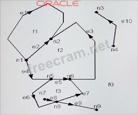
The following diagram shows an Oracle Spatial Topology example. Items labeled E1, E2, and so one are edges; items labeled N1, N2, and so on are nodes. What are items labeled F1, F2, and so on?
Correct Answer: B
Explanation/Reference:
The topology data model of Oracle Spatial lets you work with data about nodes, edges, and faces in a topology.
A node, represented by a point, can be isolated or it can be used to bound edges An edge is bounded by two nodes: the start (origin) node and the end (terminal) node.
The start node of the positive directed edge is the end node of the negative directed edge. An edge also lies between two faces and has references to both of them. Each directed edge contains a reference to the next edge in the contiguous perimeter of the face on its left side. A face, corresponding to a polygon, has a reference to one directed edge of its outer boundary. If any island nodes or island edges are present, the face also has a reference to one directed edge on the boundary of each island. Examples of geographic entities that might be represented as faces include parks, lakes, counties, and states.
References: https://docs.oracle.com/cd/B19306_01/appdev.102/b14256/sdo_topo_concepts.htm


- Question List (75q)
- Question 1: When you use tile layer, how does the map cache server provi...
- Question 2: Which command will combine two simple overlapping polygons (...
- Question 3: Which function call would return the area of a geometry, geo...
- Question 4: Which statement correctly defines the corresponding Open Geo...
- Question 5: Oracle Spatial does not have specific recommendations or res...
- Question 6: Identify three metadata tables that are used to find informa...
- Question 7: To convert an SDO_GEOMETRYobject to a GML object, special co...
- Question 8: What is the purpose of the highlighted parameter in the foll...
- Question 9: Oracle Spatial expects the ring of a polygon boundary to be ...
- Question 10: One of the best ways to optimize queries by using Spatial op...
- Question 11: Which three statements are true about the following code? (E...
- Question 12: What is the value of the return_driving_directionsparameter,...
- Question 13: In the following SQL statement, why is the DETERMINISTICpara...
- Question 14: Which statement describes the way network partitions are use...
- Question 15: What kind of geometries cannot be stored in the Oracle datab...
- Question 16: Identify two correct ways to define Spatial metadata....
- Question 18: To be able to create a partitioned index on an SDO_GEOMETRYc...
- Question 19: Which three approaches can be used to make areas of a raster...
- Question 20: What is the most effective way to compare all the geometries...
- Question 21: Which command would generalize the polygon geometry geoml?...
- Question 22: Which two statements correctly describe the storage model of...
- Question 23: Which two statements are true about 3D support in Oracle dat...
- Question 25: Which GDAL/OGRcommand will load a geotiff file named satelli...
- Question 26: Which two spatial predicates return all the cities that are ...
- Question 27: When creating a partitioned spatial index, which syntax para...
- Question 28: Identify one operation of the sdo_geom.sdo_arc_densifyfuncti...
- Question 29: In the following function, what is the location? (Exhibit)...
- Question 30: Identify two kinds of information that can be stored in an S...
- Question 31: Which two predicates would you use to find the land parcels ...
- Question 33: What is the mandatory step in order to access an external We...
- Question 34: Which control file begindatablock will successfully add a po...
- Question 35: Identify the partitioning type that is supported in Oracle S...
- Question 36: What does your application need to do to take advantage of p...
- Question 37: In the following SQL statement, what is the criteria used fo...
- Question 38: Identify four OGC vector data formats that Oracle Spatial ca...
- Question 39: What is the most efficient, easiest, and fastest mechanism f...
- Question 40: When working with bounds and tolerance for geodetic data, al...
- Question 41: You define a theme based on street line features. But you do...
- Question 42: MapViewer uses many parameters to configure its behavior. Id...
- Question 43: When using a partitioned index on a spatially partitioned ta...
- Question 44: Which two statements are true about Spatial operators?...
- Question 45: What does Oracle Spatial use to generate the R-tree spatial ...
- Question 46: To refresh workspace E1 you use the command DBMS_WM.RefreshW...
- Question 47: Why do you need to use the SDO_WFS_LOCK.registerFeatureTable...
- Question 48: Which two data providers have data available today for the O...
- Question 49: The J2EE geocoder processes geocoding requests and generates...
- Question 50: Which technique will allow multiple georaster objects to be ...
- Question 51: What is the following query best suited for? (Exhibit)...
- Question 52: The MapViewer administration console can be used to define a...
- Question 53: Always store two or three dimensional point data in SDO_POIN...
- Question 54: Consider the following procedure: (Exhibit) Which statement ...
- Question 55: Which technique does not enable parallel spatial queries?...
- Question 56: Which three statements are true about what is included in th...
- Question 57: You have defined a number of Web Map Service (WMS) and Web F...
- Question 58: Which command will update the spatial extent associated with...
- Question 59: Which two requests will you use to update records in a catal...
- Question 60: When you enable versioning using the DBMS_WM.EnableVersionin...
- Question 61: In the following SQL statement: (Exhibit) What syntax should...
- Question 62: Which procedure can be used to validate and correct most geo...
- Question 63: (Exhibit) The following diagram shows an Oracle Spatial Topo...
- Question 64: Which statement is true about the networks managed by the Or...
- Question 65: How is the outer ring rotation defined?...
- Question 66: The Spatial routing engine must have the following tables in...
- Question 67: Identify two compression types that are not natively support...
- Question 68: The match mode for a geocoding operation determines how clos...
- Question 69: The SDO_TOPO_MAP.CREATE_FEATUREfunction is used to load topo...
- Question 70: In Spatial Analysis and Mining, what does the term binning m...
- Question 71: Which two are benefits of partitioning in Oracle Spatial?...
- Question 72: There are several ways to create tables for a network. For w...
- Question 73: Which command will load a shapefile named states.shpby using...
- Question 74: The Spatial geocoder schema is made up of seven data tables ...
